Articles from the Thoroton Society Newsletter
A Kneeton Enigma
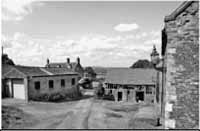
Hall Farm Kneeton - Centre far distance lies Ramsdale Hill in the pre-Conquest royal manor of Arnold, overlooking the Dover Beck Valley to its right. The threshing barn lies on the right of the picture; the barn beyond is a listed feature.
The Kneeton feature is a turret-shaped, pillar-like structure, see picture below, standing in a steep gulley beside a trackway leading down to an old Trent ford and a nearby ferry point over to Hoveringham. The turret feature which has been covered in undergrowth has now been cleared and opened up by the farm tenant at Hall Farm, is said to have been constructed to aid the turning of a draft horse after hauling a wagon into the adjacent threshing barn which is built on the edge of the gulley. This feature has been constructed out of the same stone material as the lower course of the threshing barn, the lower courses of adjacent building, walls and the church graveyard wall. The upper courses of the barn are larger than normal but uniform sized brick. Hall Farm was the site of a so-called mansion-type building demolished in the late 18th century.
What is of interest is that according to a 13th document, the site of Hall Farm must once have consisted of a fortified site of some description. The fortification could possibly be Anglo-Saxon, as the Nottinghamshire Heritage site index contains no record of a known postConquest fortified site at Kneeton. The document dated 1270 (1), mentions an “Un(d)ercastelbylhenedes” and deals with a “selione” or strip of land under the end nearest the “castel” promontory. Hall Farm and the adjacent St. Helen’s church are located on the top of triangular shaped promontory, the “byl” part of the name. The English Place Name Society at Nottingham University have confirmed that O.E. Castel was in use pre-Conquest.
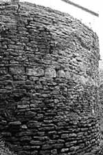
The turret shaped feature alongside the trackway leading down to the Trent crossing at Hall Farm Kneeton.
It cannot be said at the moment that the turret-shaped feature has any connection with the name of Unercastelbylhenedes; there is this coincidence however. A further possible co-incidence occurs downstream in the neighbouring parish of Flintham. Here, 13th documents (2) mention a “Castel en le Breekes”and “Castel Medue,” that have been documented in the Thurgarton Cartulary by Trevor Foulds. Foulds identifies the area as Ash Close where vague earthworks were visible close to where Long Hedge Lane descends the ridgeline to cross the Trent at Hazelford, (see Map 6 and Flintham text in the Thurgarton Cartulary). Once again the Nottinghamshire Heritage site index contains no record of a post-Conquest fortified site at Flintham. Further possible circumstantial evidence occurs in the later field names in the Ash Close locality of Bald House Slaid - 1775 (3), derived from M.E. Balled, rounded, and Roundhouse Plantation - 1887 (4). The Flintham ridgeline here according to field name evidence also contained a beacon site (Beacon Close). Unfortunately both Ash Close and Beacon Close fall within the area of RAF Syerston.
These two river crossings in conjunction with the neighbouring East Bridgford and Shelford crossings were, it appears, of immense strategic importance, part of the Anglo-Saxon civil defence of the Five Boroughs during the 10th century. In addition of course there is a motte and bailey type construction known from Pancake Hill at East Bridgford that possibly utilised Anglo-Saxon defences; late Anglo-Saxon pottery was found on site. Pre-Conquest routes known as the Ferdgate and Herryway, both meaning army road, came up through Leicestershire to this group of crossings. Hence the probable need to construct fortified sites here to defend and control the crossings. Modern academic research is now indicating that routes such as the Ferdgate and Herryway were used by advancing English armies and reinforcements and not by Viking forces as once thought.
The Domesday Book records that the three thegns who held Kneeton in 1066, AElfsige, Wulfric and Wulfgeat, also held manors across the river in Epperstone and Woodborough. These two parishes contain the access routes off the old London to York road (A60 & A614) down the Dover Beck Valley to the group of Trent crossings in the Kneeton area. The Kneeton ridgeline containing a toot-site, has sight lines across into the Dover Beck Valley. This would have given the thegns the capability of not only controlling the fords but their access routes as well. Similar situations occurred in the Domesday entries for the Shelford/Stoke crossing, and the East Bridgford and Flintham crossings.
Watch towers were a known feature of Anglo-Saxon civil defence, but even if the Kneeton turreted feature is unconnected to the name of Unercastelbylhenedes, there is still much co-incidental evidence in the form of the Domesday entries and minor place and field names in the area to be ignored from this little known part of Nottinghamshire’s pre-Conquest history.
Notes
1. Unercastelbylhenedes - Kneeton - Nottingham University Manuscripts Dept. Ref No Mi D 594/1-1270
2. Castel en le Breekes. - Flintham - British History Online, Catalogue of Ancient Deeds, Vol 3, A5602 late 13c. Castel Medue - Flintham - British History Online, Catalogue of Ancient Deeds, Vol 4 A6129 1271.
3. Bald House Slaid - Flintham - Nottinghamshire Archives Ref No FT 1L, 1775
4. Round House Plantation - 1887 Ordnance Survey 1inch map. Ivan Morrel
< Previous