Articles from the Thoroton Society Newsletter
Lenton Priory Update: A Community Geophysical Survey
By Paul Flintoft
Up until the recent excavations which were undertaken by Trent & Peak Archaeology as part of a programme of utility diversions for the NET2 project, it was widely believed that much of Lenton Priory had been almost completely demolished (McAree, D.2003). However, as reported upon in the last newsletter, direct observations from the investigative slots have now shown that structural remains of the main Priory church have survived, at least along Old Church Street and on the peripheries of Priory Street (Hobson, M and Flintoft p. 2013). These unexpectedly positive results have been excitedly received by the Lenton Local History Society, city councillors and local residents alike, who have recently participated in tours around the areas around the former priory as part of the CBA Festival of Archaeology.
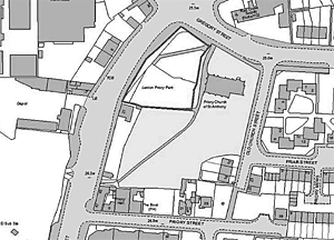
Subsequently, Trent & Peak Archaeology were contracted by Nottingham City Council and the Lenton Local History Society, with the support of English Heritage, to undertake a geophysical survey of the churchyard, green spaces and parks on the site of Lenton Priory (Figure 1). Very little is known about the preservation of the priory and other remains in these areas, and it was hoped that the surveys would be of great use for assessing not only the potential levels of physical preservation, but also the organisation of space within the wider monastic complex. Furthermore, positive results could also be used to establish a burgeoning project of archaeological research and heritage management for the Priory, which is expected to include a partnership between academic institutions and interested members of the local community.
A total of 22, 20m x 20m grids were surveyed across five separate areas with a Geoscan FM36 gradiometer and a Geoscan RM15 resistivity instrument. The work was co-ordinated by TPA and carried-out by students from the University of Nottingham Department of Archaeology and members of the Lenton Local History Society. The five surveyed areas include the churchyard of the Chapel of St. Anthony, Priory Park, two green areas to the east and west of Old Church Street and the garden of the Boat Inn public house.
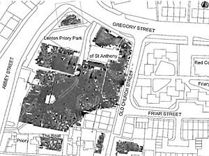
The surveys within Priory Park and the churchyard revealed a great deal of anomalies believed to represent buried features of archaeological interest (Figure 2). The resistivity survey (which detects changes in electrical conductivity in the ground) identifed a series of north-west aligned linear anomalies which may form at least three enclosures.
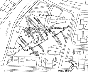
A collection of anomalies towards the western extent of the churchyard are thought to form an enclosure ditch (Enclosure 1) with potential internal partitions (Figure 4).
A series of anomalies on the same orientation as Enclosure 1 - but to the north east - are believed to represent a second ditched enclosure (Enclosure 2). This may have been intended to surround the Chapel of St. Anthony. Both of these anomaly groups align well with the majority of medieval features identifed in the recent excavations on the corner of Abbey Street and Gregory Street. It is therefore suggested that both of these enclosures are medieval in date.
A further enclosure identifed towards the northern extent of the churchyard (Enclosure 3) may post-date the two medieval enclosures (Figure 4). This anomaly not only appears to truncate the earlier anomalies, its north east aligned arm also seems to run through the site of the Chapel of St. Anthony. This feature may therefore post-date the partial demolition of the chapel.
The magnetometry survey (which detects changes in the magnetic properties of the ground) largely corroborated the results of the resistivity survey. As well as the previously discussed anomalies, anomalies extending from the sourthern limit of the churchyard may refect demolished stone structures of uncertain date and function (Figure 4).
The surveyed areas to the east and west of Old Church Street and the garden of the Boat Inn revealed further anomalies. These may relate to buildings at the east end of the main Priory church, or activities associated with earlier excavation trenches (Green, H. 1936 and Bishop, M. 1977).
The results from the community-led geophysical surveys present us with a wealth of new information. Using these results, we can now help English Heritage and the City Council with their ongoing management of this important but enigmatic site. We can also begin to pose new research questions which, in future years, might be addressed by professionals and volunteers alike. Moving forward, we hope that the concerted efforts of this new partnership of local volunteers, heritage professionals, the City Council and academics will formulate a valuable programme of archaeological research and heritage management at Lenton Priory which might include further exploration and certainly interpretation of the site.
As an initial next step, there will be a presentation and public consultation in association with Lenton Local History Society where any interested parties can put forward ideas for the future involvement of the Priory. Details of this meeting will be available on the Trent & Peak Archaeology website once a date is finalised.
Bibliography
Bishop, M. 1977. Unpublished notes held at the Nottingham City HER, Brewhouse Yard.
Green, H. 1936. “Lenton Priory’: Transactions of the Thoroton Society of Nottinghamshire 40, 75-90
Hobson, M and Flintoft, P. 2013. Report on an Archaeological Investigation of Lenton Priory, Lenton, Nottingham. Evaluation scheme, Watching Brief and mitigation strategy on Priory Street and Old Church Street, Lenton (LPX). Trent & Peak Archaeology, 2013 held at the Nottingham City HER, Brewhouse Yard.
McAree, D. 2003. An Archaeological Evaluation at Priory Street, Nottingham. Northampton: Northamptonshire Archaeology, 2003.
 |
 |
| Figure 1. The five survey areas | Figure 3. Interpreted magnetometry survey |
 |
 |
| Figure 2. Interpreted resistivity survey | Figure 3. Interpreted magnetometry survey |
< Previous