Articles from the Thoroton Society Newsletter
Nottinghamshire Domesday Book Anomalies.
By Ivan Morall
(A full version including sheets of references is available from the Editor)
In the original Domesday survey of Circuit VI, which included Nottinghamshire, it was normal practice for all land where possible to be designated as either a manor (“M”), a berewick (“B”) or sokeland (“S”) in the left hand margin of the manuscript. Sometime after the Nottinghamshire volume was completed, later entries were added where it appears this practice had changed. Whether these entries of undesignated land are original or added later, investigation has concluded that some of these lands may have played a specific role in the civil defence of later Anglo-Saxon Nottinghamshire. Many were of a low tax rating and proved to be something of an enigma and of great interest to the Domesday the historian David Roffe who concluded in a personal communication that -“These odd bovates which were peripheral to estate centres are of considerable interest. I have noticed in Lincolnshire they are often associated with centres of local royal administration.”
Certain one bovate entries where the King and the Archbishop of York held jurisdiction in the Domesday Book, were possibly relay points between the King’s and Archbishop’s estates. The entry for Farnsfield under the section of the King’s Lands in the Domesday Book simply states :- “the King has one bovate of land taxable near Nottingham”. Although the entry is said to be original by Hull University’s Digital Domesday Database, no clue is given to its status. It is entered immediately after sokelands and land attached to the manor of Grimston, which in turn because of Grimstons lack of valuation, appears to have been attached to the royal/comital manor of Bothamsall. More information on this Farnsfield one bovate is given in a later entry. Here were two bovates of land taxable at Farnsfield that was sokeland of Swein’s Hoveringham manor with one plough in lordship, one bovate in the jurisdiction of Southwell Minster and the other the King, both though belonged to Southwell Hundred. It would appear then that the land was part of the demesne of Hoveringham Manor, but the King had kept jurisdiction, known as forensic soke on 1 bovate for some specific reason.
What could have been important about this land that the King kept jurisdiction over small areas. The territory we now call Nottinghamshire during the Anglo-Saxon Age was of great strategic importance, carrying the then main London to York road, the present A60 and A614. The routes for attacking armies from the North around the Humber Estuary led into Nottinghamshire via the Rossington and Whitwell Gaps to the all important Trent crossings, specifically the crossings between the Newark and Nottingham areas. Hence the importance of Nottingham and Newark as both were fortified and listed as Boroughs in the Domesday Book.
In the neighbouring parish of Oxton, listed under the “Lands of the Archbishop of York” there is another probable connected entry. Here there was a manor with a rating of six bovates to the geld held by Alnoth in 1066 and the Archbishop of York in 1086. Again for some reason the King had kept the jurisdiction on one bovate of this land, while the rest of the Oxton manor came under the jurisdiction the Archbishop’s Blidworth manor to which it was attached. Blidworth had come into the Archbishop’s possession late, along with its two attachments at Calverton and Oxton. Prior to this Blidworth had possibly been a part of the royal manor of Arnold. Blidworth formed the sight line connection between the royal manors of Arnold and Grimston along the route of the London to York A614 road; all were probably located on high ground for this reason. This Oxton one bovate along with a one bovate entry for Woodborough were later said by the 17th century Nottinghamshire historian Robert Thoroton to have been attached to the royal manor of Arnold, although not documented as such in Domesday.
Part of the parish boundary between Farnsfield and Oxton lies on the Combs Wood ridgeline, above the important road junction off the old London to York road (A614) down the Dover Beck Valley to the middle Trent crossings at Hazelford, Hoveringham and
Gunthorpe. The ridgeline lies in the southwestern part of the parish of Farnsfield, which is geographically nearest to Nottingham, vaguely conforming to the identification in the King’s Lands. The Farnsfield side of the Combs Wood ridge line both faces and is on a sight line with the site of the royal manor of Grimston at Jordan’s Farm in Wellow to which this 1 bovate was attached. The Oxton side of the ridge both faced and was on a sight line with Ramsdale Hill in the royal manor of Arnold to which it was attached. Both sides of the Combs Wood ridge were on a sight line with the Archbishop of York’s Blidworth manor who held jurisdictions there along with the King.
Whereas the royal manors in the county were all situated on high ground and in the main on sight lines with one another, the Archbishop’s main Southwell manor was not. Located at the bottom of the Greet Valley, it cannot be directly seen from Blidworth hidden behind the Edingley and Halam Hills. Yet another one bovate entry at Hockerton listed under the Archbishop’s Land appears to have formed a link and relay between the Archbishop’s Southwell and Blidworth manors via the Combs Wood ridge. Hockerton lies opposite to Southwell in the Greet Valley, and on a sight line with both Southwell and the Combs Wood ridge. Sight lines from the ridge to Hockerton today are aided by the Hockerton community wind turbine. (Plates on pages 16 and 17)The site of this wind turbine is also on a sight line from Toot Hill on the Kneeton/East Bridgford parish boundary which would have given Southwell the capability not only of connecting to Hoe Hill in its Cropwell Bishop manor via these Hockerton and Kneeton sites but also to the beacon site at Woodhouse Gorse located in Southwell’s Norwell manor, previously known as the Beacon Pits. The Hockerton wind turbine today is located in the general area of the amusingly 18th century name of Bum Stoop. This appears to be a Georgian corruption of Burntstump which was documented a century later in the same area. The name Burntstump could be loosely associated with a site of a signal beacon. This has been noted before at the former toot-site at Burntstump Country Park in the north of Arnold Parish. In addition, the Hockerton wind turbine is also on a sight line from the toot site at Loath Hill, Oxton, giving the Archbishop’s Southwell manor the capability of connecting in with Loath Hill’s sight lines into the main beacon system through the county. We must remember that the ecclesiastical estates had the same military commitments and conditions placed upon them as any other land holder in England. Documents tell us that a land holder, with five hides or more, or the thegn with a smaller estate who served as a warrior representative of a five hide unit, thought to equate to six caracutes in the Danelaw, was expected to personally contribute to the obligations of military service when summoned, fortress work and bridge maintenance, known as the Trimoda Necessitas.
Blidworth is key to understanding the situation. Blidworth along with its two attachments at Calverton and Oxton overlooked and had the capability of controlling the two junctions off the old London to York, A614 road down the Dover Beck Valley to the group of Middle Trent crossings Trent crossings at Hazelford/Flintham, Hoveringham/Kneeton and Gunthorpe/East Bridgford. The importance of these fords is shown by the military routes of the time that came up from the south, known as the Herryway and Ferdgate, which utilized this very group of crossings.
Nottinghamshire Domesday informs us that in 1066 the main Trent crossings, along with their approaches, were held by people of rank. Langford was held by Leofric son of Leofwine and Newark by the Countess Godgifu (Godiva). Lands on both sides of river in the Fiskerton area were held by Thorir’s son Hroaldr. Hazelford was part of the Archbishop’s Southwell estate, while Flintham on the opposite bank was held by Alwine in 1066 and by the King in 1086. Shelford and Stoke Bardolph were held by Toki’s son Auti while West Bridgford and Wilford were held by the Countess Gytha. Gunthorpe was held by Morcere who was created Earl in 1065, although he was never listed as Earl in the original documents, his rank was inter-lined at a later stage in Domesday. The main manor at East Bridgford was held by Odincarl while Kneeton was held by AElfsige, Wulfric and Wulfgeat.
The three adjacent east bank parishes of East Bridgford, Kneeton and Flintham, have sightlines into the Dover Beck Valley, which carried the access roads off the old London to York road (A614) from Arnold and Ollerton and the North to these Trent crossings. It is significant that the 1066 holders of East Bridgford, Kneeton and Flintham, also had holdings in the Dover Beck Valley. Odincarl the son of Alnoth who held the main manor at East Bridgford, also held one of two combined manors at Oxton along with Thurstan who also held a small manor at East Bridgford. As we have seen another Oxton manor was held by Alnoth the father of Odincarl in 1066 and by the Archbishop of York in 1086. Alnoth’s manor probably included the toot-site at Oxton, as it linked in with the Archbishop’s later Blidworth manor; from this toot-site the East Bridgford hills are visible, linking on a line of sight the two sets of manors at Oxton and East Bridgford.
AElfsige and Wulfric who held the two combined manors at Kneeton, additionally held a manor between them across the parishes of Epperstone and Woodborough with attached land at Gonalston and both held manors at Flawborough. AElfsige llling and a Wulfric Cild are both listed in the Nottinghamshire Domesday among those having full jurisdiction and market rights and the King’s customary dues of two pence over their lands. There is a strong probability that /Elfsige and Wulfric along with Odincarl and Thurstan were two sets of siblings. It is a fact, that in instances of joint tenure of a single estate or manor many were held by brothers. Equal division of an estate like Kneeton was also the norm among brothers. By the side of Kneeton church, a trackway descends the steep hillside to meadowland on the valley floor below and to the Trent ferry/ford crossing to Hoveringham. Either side of the trackway stand two farmsteads, it is tempting to think that these could have been the sites of the two Domesday manors of /Elfsige and Wulfric which were given one combined value although seperately entered. Its possible /Elfsige’s manor occupied the site of Hall Farm, as Domesday documents a church and a priest with this manor.
Other than the land attached to the King’s Flintham manor, the only other land holding in Kneeton was a manor held by Wulfgeat. Wulfgeat, like /Elfsige and Wulfric also held a manor in Epperstone and Woodborough. This cannot be co-incidental. The two routes, one from Arnold through Woodborough, Lowdham and Gunthorpe to the Trent crossing at East Bridgford, and the road from the North and Ollerton via Oxton, Epperstone, Gonalston and Hoveringham to the Kneeton crossing, have a connecting lane from Woodborough to Epperstone to utilize any of the crossing points. From Toot Hill on the East Bridgford/Kneeton boundary the Woodborough and Epperstone Hills are clearly visible, again giving the capability of controlling the crossings along with their access routes. The thegns who held this group of fords along with the routes of the Ferdgate and Herryway probably all fell under the control of the Anglo-Saxon overlord who held the nearby manor of Bingham, the Earl Tostig. Where Tostig’s Bingham manor probably controlled this mid -Trent group of fords, his other manor at Bothamsall along with its sokelands had the capability of controlling the northern route through the shire of the old London to York road.
Possibly fitting into this overall picture in this area is the East Bridgford, Gonalston, Lowdham church grouping which could have possibly been utilized as lookouts.
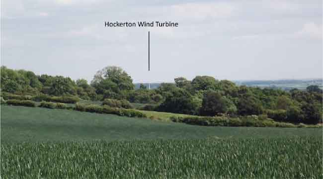 Plate 1. View of the Hockerton Wind Turbine taken from Combs Wood ridgeline.
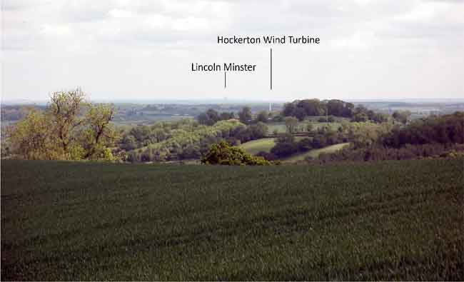
Plate 2. View of the Hockerton Wind Turbine with Lincoln Minster in the far distance taken from the toot-site at Loath Hill, Oxton.
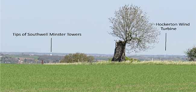
Plate 3. View of the Hockerton Wind Turbine taken from the area of Toot Hill on the East Bridgford and Kneeton parish boundary. The tips of Southwell Minster’s towers are just visible above the Greet Valley ridgeline.
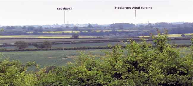
Plate 4. Zoomed image from Woodhouse Gorse, Norwell Woodhouse over to Southwell and the Hockerton Wind Turbine. Woodhouse Gorse, previously known as the Beacon Pits was part of Southwell’s pre- Conquest Norwell manor. It appears there was a relay between Norwell and Southwell in the area of Muskham Wood known from the place names of Wardecroft and Wardehillwode. The Beacon Pits linked in on a line of sight with the East Markham, Newark and Flintham beacon.
< Previous